About potepinko

Vrhnika si trova all’incrocio tra la brughiera e le Alpi Dinariche, proprio dove il passaggio più facile e difficile dal bacino di Lubiana al mare Adriatico e al nord Italia. L’idoneità del terreno all’insediamento e la possibilità di attraversamento hanno contribuito al fatto che qui si intrecciano leggende e testimonianze materiali dell’insediamento di quest’area da oltre 40.000 anni.

Il percorsso di via Gemina

Gli scavi mostrano che qui nell’antichità vi passerano carovane e rotte commerciali, si dice che il leggendario Giasone portasse la nave Argo con gli Argonauti, l’ambra veniva caricata dal Baltico ad Aquileia da oltre mille anni, e la strada giusta, la via Gemina fu costruita dai romani da Aquileia a Nauportus. a metà del I secolo. AC. Mezzo secolo dopo, costruirono una strada più breve attraverso Hrušica (Ad Pirum) fino a Emona, prosciugando le torbiere e accorciando quasi della metà il corso della Ljubljanica. Dopo la disintegrazione dell’Impero Romano, Barje divenne nuovamente paludosa e le strade si disintegrarono o furono ricoperte di vegetazione, quindi navigarono lungo la Ljubljanica per molti anni. Quando Trieste ottenne lo status di città libera (1719), i traffici tra Vienna e Trieste aumentarono così tanto che l’Impero austriaco costruì prima una vera strada imperiale (1809) e poi la Ferrovia Meridionale (aperta nel 1857). Nella storia recente, l’area tra Vrhnika e Postumia è stata dotata della prima autostrada nell’ex Jugoslavia nel 1972.

Interessante:

Da est a ovest, i Celti (III-II secolo), i Goti d’Oriente con Teodorico il Grande (inizi V secolo), gli Unni con loro re Attila al comando (V secolo), i Longobardi con il leggendario re Albione e Sassoni, Gepidi, Bavaresi, Avari e Slavi (VI secolo), da ovest a est la zona fu attraversata dai soldati romani (intorno all’anno zero), i Franchi con Carlo Magno (alla fine del IX sec.), I Francesi di Napoleone (all’inizio del XIX. secolo) e gli italiani durante seconda guerra mondiale.


Nel progetto La rete di piste ciclabili nel comune di Vrhnika o La Valle Verde di San Floriano – il comune affronta solo un segmento dell’infrastruttura turistica, percorsi ciclabili a Vrhnika con alcune estensioni ai comuni limitrofi. Nel periodo 2020-2022 non si prevedano la costruzione di infrastrutture ciclabili aggiuntive, come il noleggio di biciclette, servizi di biciclette, docce e spogliatoi, mentre le strutture ricettive sono oggetto di altri progetti. In ogni caso, le rotte prenderanno vita solo quando avremo almeno 500 turisti giornalieri a Vrhnika e potremo tenerli in hotel per un pò di più che per una cena tardiva, pernottamento e colazione anticipata. Abbiamo preso come punto di partenza il progetto concettuale della Lista za razvoj Vrhnike in podeželja (Lista per lo sviluppo di Vrhnika e delle zone rurali) “Dieci chilometri di nuove piste ciclabili all’annoil progetto da sette a dieci anni del comune di Vrhnika “.

LOKALNA KOLESARSKA MREŽA

PERCORSI CICLABILI REALIZZATI

K1 – ŽAŽAR, SMREČJE E MIZEN DOL (31,3 KM)

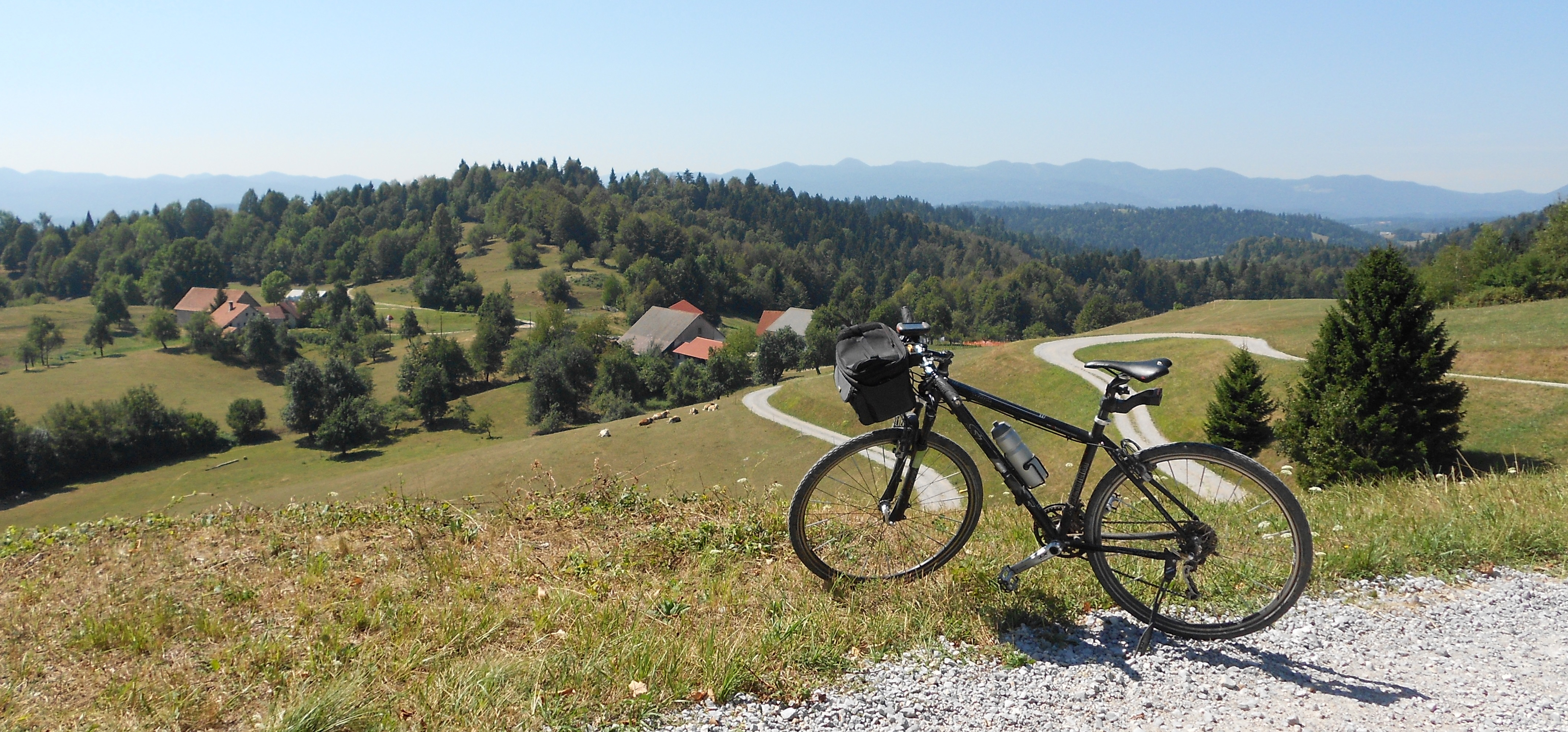
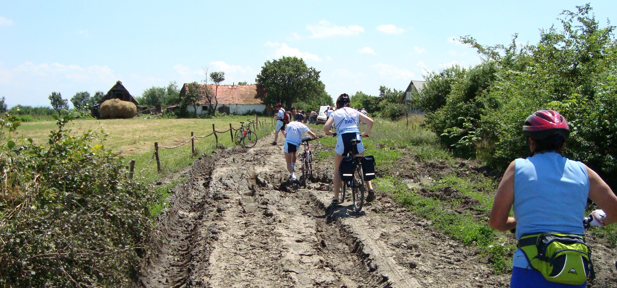
La pista ciclabile circolare K1 inizia e finisce di fronte al Centro informazioni turistiche di Vrhnika. Lungo la strada attraverserai Žažar con la chiesa di Sant’Anna e pedalerai fino a Smrečje, da dove avrai una bellissima vista tutt’intorno. Si può vedere la bellissima Chiesa dell’Assunzione di Maria, a poche centinaia di metri dall’unica locanda su questa strada. Il sentiero sale per la maggior parte fino a questo punto, seguito da una rapida discesa a Vrhnika. Il sentiero è in parte sterrato e misura 31 km di lunghezza. Per il K1, avrai bisogno di circa un’ora e mezza di ciclismo moderatamente impegnativo. Per saperne di più >>>.

K2 – KUREN E LA TORRE DI OSSERVAZIONE DI PLANINA (21,8 KM)

La pista ciclabile circolare K2 inizia e finisce di fronte al Centro informazioni turistiche di Vrhnika. Il percorso ti condurrà a Kuren, dove potrai fare una sosta in una agriturismo e vedere la chiesa di San Nicola con il suo famoso soffitto in legno e la ricca storia. Nel seguito, salirai alla torre di avvistamento su Planina, uno dei più alti edifici bifamiliari in legno della Slovenia. Segue una breve e ripida discesa lungo il sentiero sterrato fino a Stari Maln (vecchio mulino), da dove si hanno solo pochi chilometri di piacevole pedalata lungo il torrente Bela fino a Vrhnika. Il sentiero è in parte macadam e misura 22 km di lunghezza. Per il K2, avrai bisogno di circa un’ora e mezza di ciclismo moderatamente impegnativo. Per saperne di più >>>.

K3 – PISTA CICLABILE PER PODLIPA (9,0 KM)

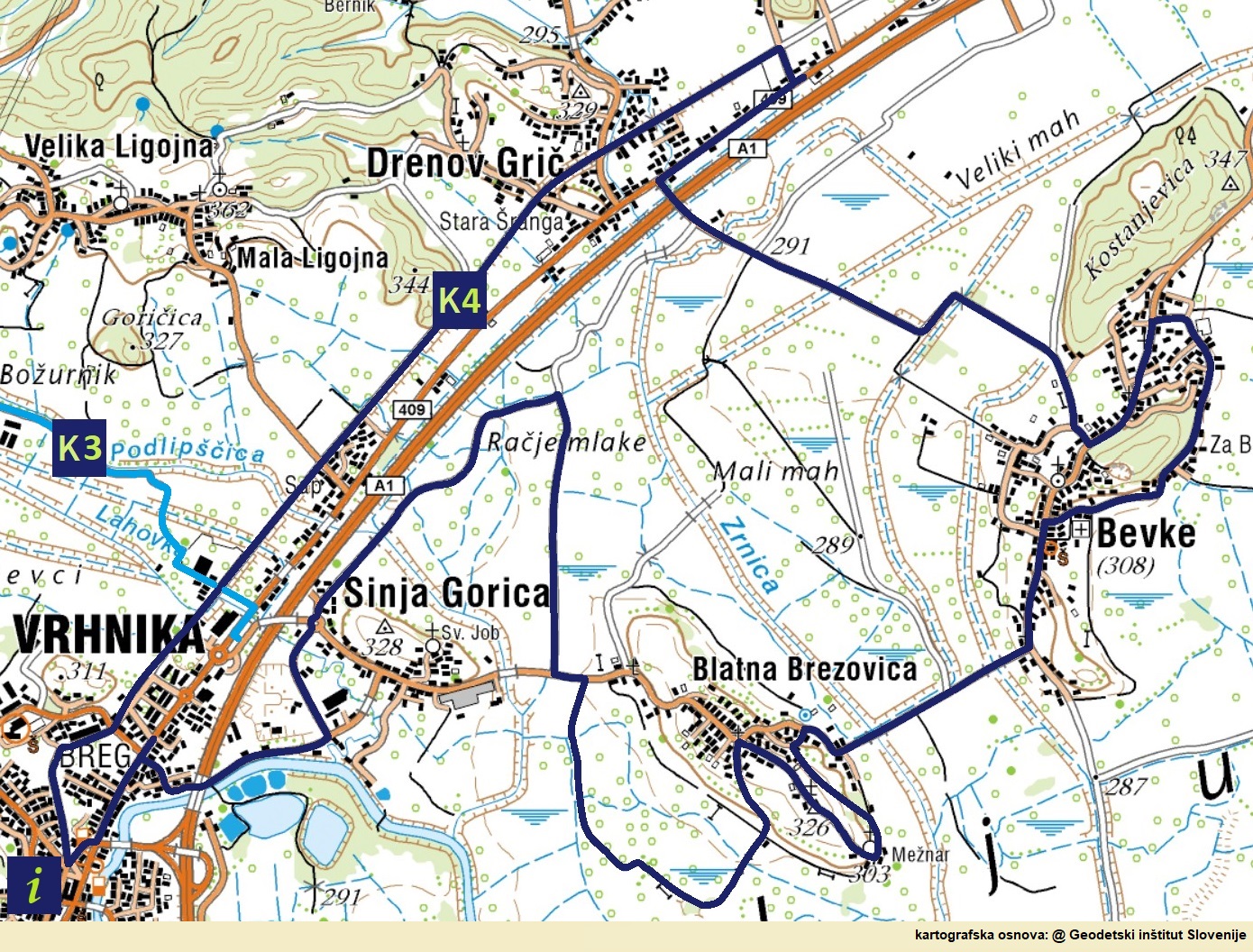
Il percorso inizia (o finisce) presso il parcheggio P&R (Park & ​​Ride) di Sinja Gorica. Il sentiero conduce principalmente lungo il letto regolato del torrente Podlipščica. Quest’anno abbiamo completato il percorso per Podlog, e l.anno prossimo completeremo il percorso presso la Chiesa di S. Bricius e Podlipa. A Podlipa si può raggiungere la pista ciclabile K1 se si percorre la strada asfaltata per circa un chilometro in direzione di Smrečje. Puoi anche unirti al K1 al nuovo ponte pedonale su Podlipščica (svolta verso la strada principale Vrhnika-Podlipa). Per saperne di più >>>.

K4 – LA STORIA DEL TRASPORTO (22,1 KM)

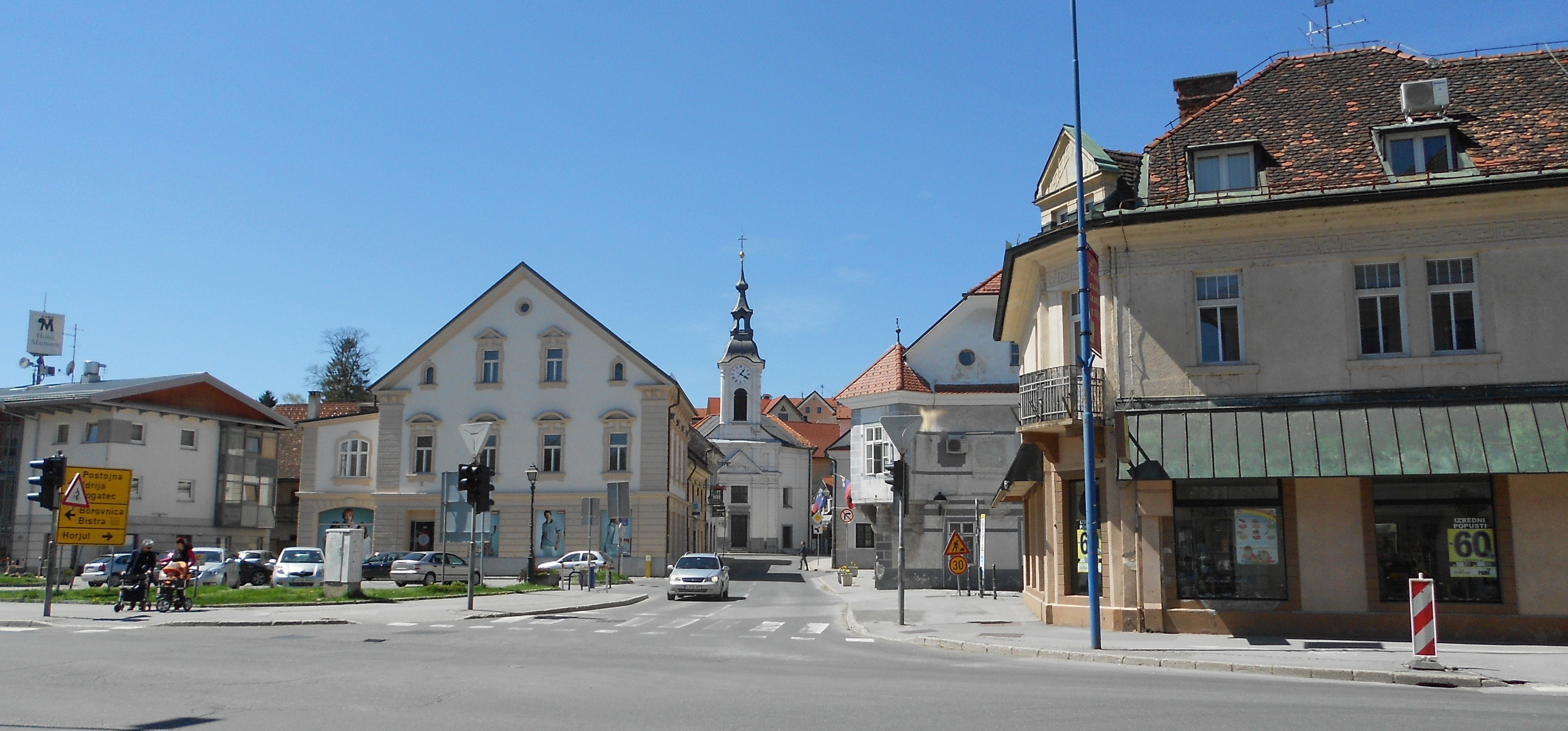
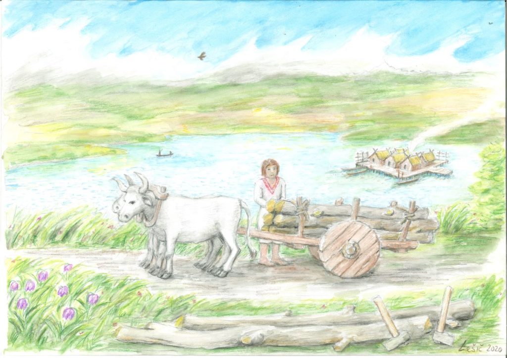
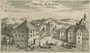
Vrhnika si trova all’incrocio tra la brughiera e le Alpi Dinariche, proprio dove il passaggio ė più facile dal bacino di Lubiana al mare Adriatico e al nord Italia. L’idoneità del terreno per l’insediamento e la possibilità di attraversamento hanno contribuito al fatto che qui vengono utilizzati vari mezzi di trasporto per più di 5.000 anni. La pista ciclabile ad anello inizia dalla “nuova stazione ferroviaria” a Vrhnika e conduce in senso orario attraverso Sinja Gorica, Drenov Grič, Bevke, Blatna Brezovica e di nuovo attraverso Sinja Gorica fino a Vrhnika. Per saperne di più >>>.

K5 – IL SENTIERO DI MERCURIO (8,5 KM)

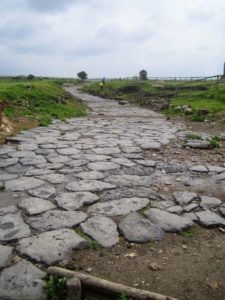
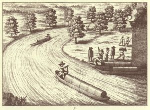
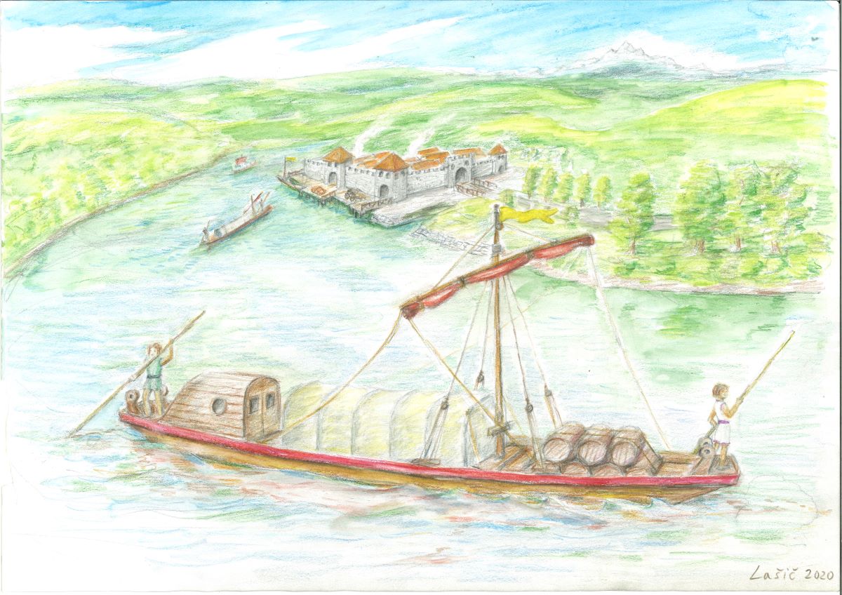
La strada che collega Idrija con Vrhnika fu costruita intorno al 1508, subito dopo la scoperta del mercurio (1493), e fino al 1721 fu l’unico collegamento stradale da Idrija. Ha lo scopo di fornire alla miniera legname, attrezzature, cibo e il trasporto di minerale di mercurio nel mondo. Parte dal dal castello Gewerkenegg a Idrija attraverso Kovačev Rovt fino a Zaplana e Vrhnika. Per saperne di più >>>.

 * la posizione deve essere attivata sul telefono


In the tenth millennium BC, the area of today’s Ljubljana Marshes is covered by a lake, which is already inhabited by pile-dwellers. For transport by water or to the shore, they already know how to squeeze a tree from one trunk. For this time-consuming work, they use tools mostly made of stone or cornea, and the interior is also hollowed out by burning. In the Copper and Bronze Ages, they already use simple axes. So far, over sixty logs or trees have been discovered in Barje, most of them younger, which means that the tree was used as a means of transport until the Middle Ages. So far, four trees from the mound period have been confirmed by the dendrochronological method.

5.200 years old wheel with axle

There are many logboat trees in the pre-Alpine world, so we should be particularly proud of the 5200-year-old and thus the oldest discovered wooden wheel with an axle in the world, which was excavated in 2002 in Stare gmajne near Verd. The wheel and axle are part of the cart (ciza), made and used in the younger phase of the settlement of the mound. The wheel, with a diameter of 71.2 cm, is made as a full disc with a rectangular hub made of two boards made of ash wood from a more than 80-year-old tree and connected in width with four ridge slats. It is part of a wagon or ciza, suitable for the hilly landscape, which includes the hinterland of the then lakeside Ljubljana Marshes. Pile-dwellers use it either to transport captured game or to transport field crops to the edge of the lake. They are already using draft cattle to transport the wagon.


Local Community Drenov Grič – Lesno Brdo

The local community of Drenov Grič – Lesno Brdo (6.50 km2, 1,300 inhabitants, 291 m above sea level) stretches on the western edge of the Ljubljana Marshes and consists of the settlements of Drenov Grič (750 inhabitants) and Lesno Brdo (550 inhabitants).

The village of Drenov Grič began to form after the construction of the second imperial road in 1809. Thus, at the beginning of the 19th century table. there are almost no houses along Tržaška cesta from Sinja Gorica to Log. Where there is a turnoff for Horjul today, there is a house-inn with a stable, called Pri Stari šrangi. There is an inn in the eastern part and a cattle barn in the western part. At that time, distant and nearby farmers loaded a lot from Ljubljana to Trieste and the inn was well visited. As the barn soon became too small, in 1816 a new one was built next to the house along the road for 50 pairs of horses and oxen. The barn still stands today. It was not until around 1830 that the first residential house was built next to the inn, and then by 1838 five more. People from distant and surrounding places call this small settlement after the inn Stara šranga. Around 1898, a local line of the Ljubljana-Trieste Southern Railway was built through the settlement, leading to Vrhnika. In those years, the number of houses in the village increased sharply, and the material situation of the inhabitants improved. The village is supposed to be named Drenova Gorica at that time, but it will soon be renamed Drenov Grič.

Kucler’s quarry

Lesno Brdo is divided between the municipalities of Vrhnika (southern part) and Horjul (northern part). Above the main part of the village there are three quarries, the largest is still in operation, two smaller ones are abandoned. Due to geological peculiarities, Kucler’s quarry is protected as a natural monument.

Interesting:

In five millennia, all land routes and waterways on the pile-up lake run through the area of ​​the local community, only the navigable Ljubljanica is too far.


Roman consular road

The Romans attached great importance to traffic and especially to road connections. So it is no wonder that as early as around 450 BC, road construction was standardised by law. This determined, among other things, the width of the road at 2.45 m on straight sections and 4.90 m on bends (later the construction of roads between 4.0- and 6.0-meters wide is introduced, so that two carriages can meet), the rules for paving and the right to use private land (easement)..

According to importance, Roman roads are divided into public, side, local and private roads. As a rule, public roads are built as straight as possible, so in some places the slopes reach 20%. Minor obstacles on the planned route, e.g. hills, are removed, tunnels are dug into larger rocky hills and bridges are built over rivers, for which the Romans are true masters. Along the roads at a distance of one mile (thousand (double) steps or 1,478.5 meters), they place round two-meter high milestones made of a single piece of stone. The golden zero milestone (miliarium aureum), from which the distance from Rome is counted, is placed in the centre of the Forum.

Roman findings near via Gemina in Vrhnika

With the via Gemina, the Romans connect Aquileia with Emona. The section between Nauportus and Emona is built between 14 and 9 BC XIII. Roman Legion – Legio XIII Gemina. According to the finds, the Roman road in Vrhniško descends steeply from Stampeta’s bridge to the five-sided fortress on Hrib, bypassing the (today’s) Church of St. Paul on the south side, crossing Hribski potok south of today’s bridge and leading in a straight line to Stara cesta near the former smithy. To the Church of St. Lenart, the routes of the Roman and Stara cesta overlap, then the road continues below Hrušovca to Frtica and further in a straight line to the Church of St. John at Log..

Interesting: At the end of the Roman Empire, 372 public roads were built over a length of 80,000 km on three continents, from Scotland to Mesopotamia and from the Atlantic to the Red Sea.


Preparations for the construction of the first section of the motorway in Slovenia have been going on for five years, and on 29 December 1972 the 32 km long motorway section between Vrhnika and Postojna was handed over to traffic. With this project, Slovenia or the former Yugoslavia joins twenty European countries that already have motorways. Workers from all Yugoslav republics are taking part in the construction, mostly from Macedonia, from where they were driven by the desire for higher earnings. Construction divided into three subsections (Vrhnika-Logatec, Logatec-Unec and Unec-Postojna).

On the Vrhnika-Logatec section, the initial part near Vrhnika causes problems for workers due to the unfavorable geological base. Like the builders of the Southern Railway, the builders of the motorway section have problems with the swampy soil of the Ljubljana Marshes. With the preloading process, they cause forced subsidence of the ground, thus preventing subsequent deformations of the road. Five overpasses, four underpasses and the Verd viaduct (630 m) are being built on the section. Most of the headaches and related delays cause contractors to break through the Štampet Bridge.

Interesting:

All facilities on the bog soil are built on piles, which due to the variability of the terrain reach between 15 and 40 meters in depth.

construction of the first motorway (Source: Archive of DARS d.d.)


VRHNIKA ON A POSTCARD FROM 1901 (SOURCE: CANKAR’S LIBRARY OF VRHNIKA)

The construction of the second imperial road is being undertaken more professionally, with the participation of civil engineers, miners, military workers and military officers, masons, carpenters, etc. and no longer by pressure. The road is designed so that it does not exceed a slope of 4%, which is supposed to mean that strapping was no longer necessary. Plans for a new road were prepared by the construction director Jožef Šemerl in 1793. The construction of the road began in Planina in 1803, and it took three years to reach Vrhnika for 24 km. Between Vrhnika and Logatec it runs in a completely new direction, the road is macadam, paved with cubes only after the Second World War.

VRHNIKA ON A POSTCARD FROM 1918 (SOURCE: CANKAR’S LIBRARY OF VRHNIKA)

There are two toll booths in operation in Vrhnika at this time, and carriers try to avoid paying tolls by turning from the Imperial Road to Idrijska cesta and the surrounding cart tracks, while road workers prevent evading payment by digging forest paths and digging ditches, by erecting walls along the road. and with high penalties.

The new road leading from Vienna to Trieste is a wide and flat enough road to transport cargo with the same large carriage with several pairs of horses all the way, so the volume of truck-related activities is greatly reduced, and workers in the port lose their jobs. only bricks and wood are loaded on the Ljubljanica.

Interesting:

Even before the new road was finally arranged, Napoleon’s soldiers descended from Planina on 19 May 1809. They don’t leave a very good impression after four years, as they steal everything they can get their hands on.


Attila the Hun, he ruler of the Huns from 434 until his death in March 453.

The Roman roads between Emona and Aquileia are deteriorating uncontrollably and the cargo between Vrhnika and Ljubljana is beginning to be redirected to the Ljubljanica. In Vrhnika, they transfer cargo from ships or boats to horse backs (and vice versa) and load it towards Trieste. Milling is also booming, as a load of flour is more expensive than a load of grain and it is easier to bear the high costs of loading over long distances.

With the development of carting, other activities are also developing, such as blacksmithing and animal husbandry, wheel making and saddlery. Merchants and innkeepers serve by renting sheds for harvesting goods, barns for livestock, haylofts, lodgings for trucks and food. The inn business is mainly run by large farmers, but also by the pastor and market dignitaries, as well as the mayor, postman and judge. Inns are the center of events in every place, including Vrhnika, where news and stories are exchanged, and they are often the place where diseases are transmitted.

Mail carriage (academic sculpturer Jože Lašič)

Cart-making becomes a lucrative business, but lords face many dangers, the biggest of which are bandits, so they join larger caravans on the way. The most dangerous section to Trieste is the pass between Planina and Postojna, which has retained the sinister name Ravbarkomanda (bandit-control-point)) to this day.

BY THE END OF XIX. CENTURY VRHNIKA IS DIVIDED INTO THREE INDEPENDENT SETTLEMENT CORE – BREG, HRIB AND VAS. VRHNIKA STATUS OF THE PLACE IN 1955

Interesting:

In 1719 Emperor Charles VI. orders the renovation of a narrow old road that ran from the port of Breg, across the village and Hrib. Renovations are being undertaken very unprofessionally, so the new slopes are steep 20% and more. Due to the steep slopes, a new market niche opens up for the people of Vrhnika – strapping and lending horses on ascents and gliding (braking) on steep descents.


The port of Vrhnika-Breg (J. V. Valvasor, 1689, copper engraving)

The Ljubljanica is not a large river, its entire course measures only 43 km, but it has been the most remarkable waterway in Carniola since ancient times. Valvazor also writes about boating – the Ljubljanica is full of boats that transport all kinds of goods that come from Italy and are sent to Italy. Written sources mention the year 1489, when Emperor Frederick granted large boatmen a special privilege – the freedom to sail on the Ljubljanica.

Goods are transported in small and large boats. With small boats hollowed out of a single trunk, they carry up to 30 cents (1680 kg) of cargo. With about seven meters long boatmen or roofers (boats with a roof) they transport people, and with an even longer sandblaster they transport sand. Large boats are up to 20 meters long and carry up to 300 cents (almost 17 tons) of cargo.

SAILING IN LJUBLJNICA RIVER (J. V. VALVASOR, 1689, COPPER ENGRAVING)

Two ports are being built in Vrhnika, for passengers it is being built at the former post office, toll booth and inn – Lavrenčič’s house – near the bridge to Verd, and a cargo port opposite the former Roman port. Traffic on the Ljubljanica declined considerably after the construction of the Imperial Road in 1728, after the construction of the road in 1809 only wood and bricks were transported from Vrhnika to Ljubljana, and after the construction of the Southern Railway (1858) traffic on the Ljubljanica completely died out.

Interesting:

Eminent travelers, such as the emperors Leopold I (1660), Charles VI (1728) and Franz I (1821) also arrived from Ljubljana to Vrhnika by the Ljubljanica river.


Roman ship with Nauportus in the background (academic sculptor Jože Lašič)

Evidence shows that after the last glaciation, the Ljubljana Marshes covered the lake. This shrank over the millennia and in the middle of the 2nd millennium BC only a large swampy plain remains, through which the Ljubljanica winds lazily.

JAZON SHOULD BE ARRIVED BY THE SHIP NAMED ARGO TO THE SOURCE OF THE LJUBLJANICA IN THE MOČILNIK AROUND 1222

According to legend, the Ljubljanica was navigable as early as the 2nd millennium BC, as the Argonauts were supposed to sail along it from the Black Sea across the Danube and the Sava all the way to Vrhnika. As a navigable river, it gained importance with the arrival of the Romans in the middle of the first century BC, when they built the settlement of Navport, intended for the transshipment mainly of military equipment for the Roman legions, which penetrated towards the Danube, from wagons to river ships. Numerous finds also testify to this. As early as 1890, a Roman cargo ship from the first century BC was discovered near Črna vas and in 2008 in Sinja gorica another one, the specialty of which is the technique of joining with iron couplings, which is a missing link in research into the technology of construction of the Mediterranean type of vessels and the development of shipbuilding in general. With the completion of the occupation phase of the Roman legion in Pannonia and the construction of the Navport-Emona road, the importance of the waterway for the Roman army diminished but did not die out.

RECENTLY DISCOVERED ONE OF THE LARGER LOGBOAT FROM II. CENTURY BC INDICATES THAT TAURISCI WERE ALREADY SAILING ON LJUBLJANICA AT THAT TIME

Interesting:

As the Greek writer Strabo mentions, it was already in the middle of the 2nd century BC in the wider area of Vrhnika there was a settlement called Nauportus (Nauportus – navis, portus – port) in a Latin form.